Research Article |
|
Corresponding author: Claudia Patricia Ornelas-García ( patriciaornelasg@gmail.com ) Academic editor: Horst Wilkens
© 2023 Ramsés Miranda-Gamboa, Luis Espinasa, María de los Angeles Verde-Ramírez, Jorge Hernández-Lozano, Jean Louis Lacaille, Monika Espinasa, Claudia Patricia Ornelas-García.
This is an open access article distributed under the terms of the Creative Commons Attribution License (CC BY 4.0), which permits unrestricted use, distribution, and reproduction in any medium, provided the original author and source are credited.
Citation:
Miranda-Gamboa R, Espinasa L, Verde-Ramírez MA, Hernández-Lozano J, Lacaille JL, Espinasa M, Ornelas-García CP (2023) A new cave population of Astyanax mexicanus from Northern Sierra de El Abra, Tamaulipas, Mexico. Subterranean Biology 45: 95-117. https://doi.org/10.3897/subtbiol.45.98434
|
Abstract
The Astyanax genus represents an extraordinary example of phenotypic evolution, being their most extreme examples the blind and depigmented morphs, which have evolved from independent surface-dwelling lineages. Among cave organisms, Astyanax cavefish is a prominent model system to study regressive evolution. Before this study, 34 cave populations were known for the Astyanax genus to be inhabited by the cave morph. The majority of those cave populations are distributed in Northeast México, at the Sierra Madre Oriental (32 cavefish), in three main areas: Sierra de Guatemala, Sierra de El Abra, and Micos, and two in the Balsas basin in the state of Guerrero, Mexico. In the present study, we describe a new cave population found 4.5 km Southward of Pachón cave, the most northern cave population known for the Sierra de El Abra limestone. El Refugio cave is a resurgence with a mixed population of fish with different levels of troglomorphism, and surface fish, resembling other hybrid populations within the Sierra de El Abra. Based on a mitochondrial DNA characterization of the 16S ribosomal DNA sequence, we could identify the mitochondrial lineage of this population, which was placed closely related to the “New Lineage”, sharing haplotypes with the surface (i.e. Arroyo Lagartos) and Pachón populations, instead of with the cave populations from Central Sierra de El Abra (e.g. Tinaja cave). El Refugio cave population gives additional evidence of the intricate history of this system, where migration, drift, and selection have shaped the evolution of the cave morphs through the independent episodes of the Astyanax mexicanus history.
Keywords
Astyanax, cavefish, regressive evolution, repeated evolution, Sierra de El Abra
Introduction
México represents a hotspot for troglobitic diversity in freshwater fish fauna, with seven different families with troglomorphic representatives including Characidae, Dinematichthyidae, Eleotridae Heptapteridae, Ictaluridae, Poeciliidae, and Synbranchidae families (
Since the discovery of the first population of blind characins in 1936 in La Cueva Chica, in the southern portion of the Sierra del Abra limestone, by Salvador Coronado, the taxonomists of their time classified them as a new genus and species, Anoptichthys jordani (Hubbs & Innes, 1936), based on their troglobitic morphology (i.e., eye reduction and loss of body pigments). Shortly after, ichthyologists discovered another two cave populations of blind characids in the region. The first corresponds to El Pachón cave, Anoptichthys antrobius (Álvarez, 1946), and the second to Anoptichthys hubbsi (Álvarez, 1947), from Cueva de Los Sabinos, both at the Sierra de El Abra. At that time, each cave population was considered an independent episode of evolution from their surface ancestors and accordingly was described as different species. Afterward,
Due to the extreme differences between the surface and cave Astyanax mexicanus morphs, the cave-dwelling morph has been considered a model organism to explore the genetic mechanisms underlying regressive evolution, particularly, vision loss, as well as the reduction in pigmentation (
Regarding the evolutionary history of the cavefish populations of Astyanax mexicanus, multiple studies have shown evidence that cave populations have originated from two independent lineages (
With the development of genetic tools, it has been possible to characterize the evolutionary history and phylogeographic patterns of cave populations in northeastern Mexico. Among the first studies carried out with the mitochondrial DNA data, Astyanax mexicanus cavefish showed the presence of two different lineages that were named by
In the present study, a new population is described for the northern region of Sierra del Abra. A general description of its geohydrology is included. In addition, a brief description of the phenotypic variation found in the cave, and the characterization of a mitochondrial ribosomal marker (r16S) were included. Based on this information, it is concluded that this population could correspond to a mixed population, with a large phenotypic diversity in terms of the degree of regression of vision and pigmentation traits, as has been reported in other hybrid caves such as Chica. Regarding the geometric morphometric variation, we recovered El Refugio populations as intermediate between the Pachón and Tinaja caves, giving evidence about the common ancestry between the caves within the Sierra de El Abra system, despite the large introgression between the Río Lagartos surface population and El Refugio cave.
Methods
The “El Refugio” cave (22°34'28.50"N, 99°01'30.74"W, 231 masl), takes its name from the closest town in the state of Tamaulipas, México. The cave was discovered by Jean Louis Lacaille in April 2020, and troglomorphic fish were seen in some of the cave pools (Figs

a simplified map edited from
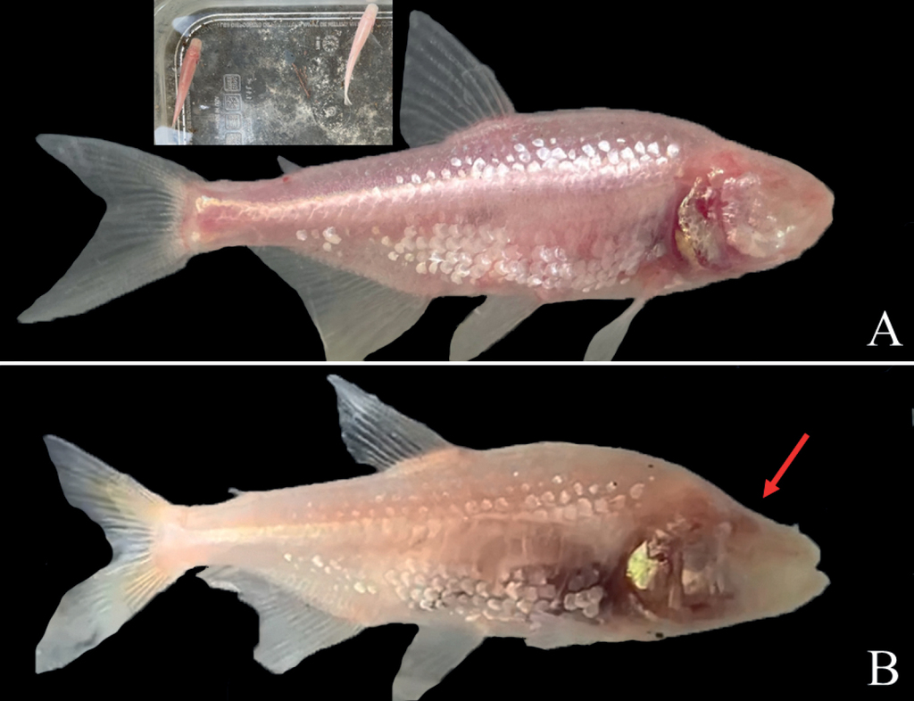
Highly troglomorphic fish are found in the El Refugio cave and in the nearby well. The two fish in the insert were found in the well-used by locals to extract water. In this well, troglomorphic fish are seen swimming under the sunlight. The most troglomorphic fish in this cave system have two types of colorations, pink (A) and white (B). These two colorations are shown also in the specimens in the insert. Notice also that eye regression and skull modification create a downward hump in some specimens (red arrow).
To explore the El Refugio cave, a cable ladder was also employed to access its 2 m entrance pit. The cave was surveyed using a DistoX2 device, and the TopoDroid app on a tablet. Survey data were processed using Visual Topo ver. 5.17, and drawn using Adobe Illustrator. To capture specimens, hand-held nets were used. Photographs were taken in the field with the help of a small glass tank and an iPhone 11 camera. A small fin clip was taken with scissors for DNA studies from all specimens. Voucher samples were stored at the Colección Nacional de Peces, IBUNAM, Mexico.
For the collection of cave specimens, permission was obtained from the competent Mexican authorities (SEMARNAT SGPA/DGVS/03334/22). All of the fish collected were kept alive in the laboratory of Patricia Ornelas-García, IBUNAM, for breeding in captivity, which can serve as a stock for future studies.
Genomic DNA samples were obtained following standard methods for DNA purification using Qiagen’s DNeasy Tissue Kit by digesting a fin clip of the individual in the lysis buffer. A fragment of the mitochondrial 16S rRNA was sequenced for 6 troglomorphic, one hybrid, and one epigean fish, all collected inside the El Refugio cave. The 16S rRNA fragment was amplified and sequenced using the 16Sar (CGCCTGTTTATCAAAAACAT) and 16Sb (CTCCGGTTTGAACTCAGATCA) primer pair for 16S rRNA. Amplification was carried out in a 50 µl volume reaction, with QIAGEN Multiplex PCR Kit. The PCR program consisted of an initial denaturing step at 94 °C for 60 sec, 35 amplification cycles (94 °C for 15 sec, 49 °C for 15 sec, 72 °C for 15 sec), and a final extension step at 72 °C for 6 min in a GeneAmp PCR System 9700 (Perkin Elmer). PCR amplified samples were purified with the QIAquick PCR purification kit and directly sequenced by Elim Biopharm Genomic Services (https://www.elimbio.com/services/dna-sequencing/). Chromatograms obtained from the automated sequencer were read and contigs were made using the sequence editing software SequencherTM 3.0. External primers were excluded from the analyses. BLAST was used to identify GenBank sequences that resemble the specimens. Sequences were aligned with ClustalW2.
For comparison, DNA sequences were aligned to sequences from localities reported previously by
Morphological characterization
To characterize the morphospace of the El Refugio population and their relationship with other populations from the Sierra de El Abra, we performed landmark-based Geometric Morphometrics (GM) analysis on the lateral left-hand view of the body shape. We digitized 12 homologous landmarks and a curve with 15 pseudo landmarks with the TPSDig2 v. 2.31 (
To avoid a size effect by allometry, the residuals of the regression of the shape on the centroid size (CS) were calculated with the function “procD.lm”. Once the residuals were obtained, an allometry-free shape was created, using these residuals of the morphological data. The analyses were made on this allometry-free shape. To assess the variation in body shape, we used principal component analysis using the “gm.prcomp” function. This is an ordering analysis that captures the multidimensional variation that is inherent in body shape (
In addition, discriminant analysis of principal components (DACP) (
An Orbital Diameter Height was estimated (red line in the orbit, Fig.
Results
El Refugio cave is part of a series of resurgences (i.e., point at which an underground stream reaches the surface and becomes a surface stream) in the area that include the nearby well and Refugio cave itself. The cave shows tectonic control, and the orientation of the galleries follows the main NW-SE fault (Fig.

A general geologic map of the northern part of the Sierra del Abra showing the locations of the El Refugio and Pachón caves entrances at the geological contact between Agua Nueva and San Felipe formations (modified from Carta Geológico-Minera Ciudad Mante F14–5) B satellite view showing the principal streams near the cave entrances C detailed view of B. The cave horizontal projection of the El Refugio cave is observed in a red line as also the position of the Manuel de la Fuente Spring. In blue are stream beds that only carry water during the rainy season.
Regarding surface drainage, during the dry season water is pumped out through the well, but during the rainy season, high water volumes flow from both localities. During the rainy season, water from the Manuel de la Fuente spring and El Refugio cave resurgence join forming a creek that flows to the Arroyo Santa Rita downstream and is captured by Arroyo Lagartos (Fig.
Cave description
The El Refugio cave has a 2 m pit entrance that leads to a single gallery that develops parallel to a local fault going northwest with an average direction of 330°. The cave’s total length is 98 m and has a 4 m total depth. The cave ceilings are low, and therefore requires crawling most of the time. El Refugio is a shallow cave that acts as a resurgence in the wet season, where water floods the entire gallery and flows out from the cave entrance. El Refugio cave has a few small pools the cave forms of Astyanax mexicanus as well as surface and intermediate fishes (Fig.

During the dry season when El Refugio cave was explored, dry galleries were interspersed with some pools. The first was a very shallow puddle under a small bat colony (Astyanax pool 1 in Fig.
The initial part of the cave has a bed of sediments and guano from hematophagous bats that shelter in the cave. On the left wall of the third pool, there is a long mound of mud attached to roots coming from the ceiling or the walls, indicating a near connection to the surface (Fig.
El Refugio is an active cave that discharges water in the rainy season and as such, inside the cave, there is evidence of this. All the Refugio walls are covered with scallops showing the dynamic behavior of water (Fig.

Some important features of the cave A an underwater crevasse about 1 m long in the second pool B aforementioned crevasse on the floor leading to underwater passages C, D dissolution domes of different sizes along the cave galleries, suggesting that during rainy season, the whole cave is under water E, F examples of phreatic conducts with a typical elliptic morphology developed along fissures G calcite crystals covering the walls cave as evidence of multiple variations in the water table H view from the surface of the Manuel de la Fuente well.
As it is possible to observe in the cross sections of the El Refugio cave, has the characteristic shape of a phreatic conduct whose shape is elliptical (Fig.
Specimens
This cave hosts a mixed population; thus, we can find troglobitic (with complete loss of vision and pigment), surface and intermediate morphs. From the cave survey of the specimens that were observed in detail, 31.8% (N = 7) were highly troglomorphic specimens, with no pigment or external remnants of eyes, 54.5% (N = 12) were intermediate with either some type of eye and/or pigment, and 13.6% (N = 3) were surface-like fish. It is likely that surface fish are more abundant within the population, but since they react to light, they are more difficult to catch and swam away. The troglomorphic fish had either characteristic pinkish or white colorations (Fig.

Eye regression variations within the El Refugio population. In the figure, we can observe from entirely absent eyes (A–C), to different levels of vision regression (D–F). Regarding the body and eye regression combined we also observed a wide variation G, H eyeless and small-eye fish without pigment I, J eyeless and eyed fish with yellow pigment, and eyeless fish with a caudal black spot (K) L eyed and black spot and yellow pigment in the caudal fin.
Mitochondrial DNA
A 16S rRNA fragment of 572 bp was sequenced for six troglomorphic fish, one hybrid, and one epigean fish from El Refugio cave. All specimens analyzed have the haplotype A (GenBank# AP011982.1), identical to the Pachón cave sequence and to the local surface population (i.e., Arroyo Lagartos). When comparing El Refugio sequences to the mitochondrial haplotype B from Rascón and Tamasopo surface streams fish, El Refugio specimens differed by 2–3 bp. When we compared El Refugio sequences with Sabinos, Tinaja, and Curva caves sequences, they differed by 5 bp. Thus, our 16S rRNA sequences recovered El Refugio cave specimens closer to the northern Sierra de El Abra region, instead of the Central part of the Sierra de El Abra (Suppl. material
Morphological variation
The first two components explain 43.67% of the cumulative variance (Fig.

A PCA of the body shape of the three cavefish populations. At the end of each axis, the shape obtained by the positive and negative ends was placed. The hullboxes delimit the clusters obtained through K-means analysis. Black hullbox = cluster 1 (surface morph), Filled hullbox = cluster 2 (intermediate individuals), dotted line hullbox = cluster 3 (the most troglomorphic individuals) B comparison of the consensus shape of the El Refugio population (deformation vectors) vs. the consensus shapes of Pachón, Tinaja, and Surface (points) C boxplot of the orbital diameter corrected by the SL for the Surface, Pachón, El Refugio and Tinaja populations.
For the DAPC, a total of 38 PC were used, and based on the Silhouette method we recovered K = 3 as the optimal number of clusters (Fig.
The MANCOVA support differences among populations, but not by the centroid size or the interaction between CS and the populations (Table
MANCOVA made with GM body shape data. The asterisk is for statistically significant p-values.
| DF | Pillai | F | p | |
|---|---|---|---|---|
| Population | 3 | 1.97 | 17.12 | > 0.001* |
| Centroid Size | 1 | 0.13 | 1.28 | 0.249 |
| Pop*CZ | 3 | 0.42 | 1.48 | 0.139 |
| Residuals | 37 |
Finally, in the orbital diameter bloxplot (Fig.
Average of the Orbit diameter height (OD_H) and length (OD_L), and their respective proportions with respect to the fish’s Standard Length (SL) and Head Length (HL). All the measurements are presented in mm. The standard deviation is presented for each measurement.
| Refugio | S.D. | Pachón | S.D. | Tinaja | S.D. | Florido river | S.D. | |
|---|---|---|---|---|---|---|---|---|
| SL | 45.42 | 9.61 | 51.83 | 1.93 | 58.79 | 7.98 | 58.30 | 8.20 |
| OD_H | 2.35 | 0.77 | 2.28 | 0.24 | 2.35 | 0.35 | 5.11 | 0.81 |
| OD_L | 2.87 | 0.73 | 2.71 | 0.24 | 2.88 | 0.39 | 5.13 | 0.86 |
| HeadL | 11.90 | 2.32 | 12.62 | 0.68 | 14.02 | 1.57 | 13.72 | 2.29 |
| OD_H/SL | 0.05 | 0.01 | 0.04 | 0.00 | 0.04 | 0.00 | 0.09 | 0.01 |
| OD_L/SL | 0.06 | 0.01 | 0.05 | 0.01 | 0.05 | 0.01 | 0.09 | 0.01 |
| HeadL/SL | 0.26 | 0.02 | 0.24 | 0.02 | 0.24 | 0.01 | 0.23 | 0.01 |
| OD_H/HL | 0.20 | 0.06 | 0.18 | 0.02 | 0.17 | 0.02 | 0.37 | 0.03 |
| OD_L/HL | 0.24 | 0.05 | 0.22 | 0.02 | 0.21 | 0.02 | 0.38 | 0.03 |
The individual dot at the surface boxplot corresponded to the biggest fish (SL = 68.2 mm, with an OD_H = 5.53 mm, and OD_L = 5.5 mm), while for the El Refugio the individual dot corresponds to a surface-like fish, with completely functional eyes (SL = 70.6 mm, with an OD_H = 4.24 mm, and OD_L = 4.49 mm, Suppl. material
Discussion
Since the discovery of the first cave population of Astyanax mexicanus in 1936 at La Cueva Chica, the history of cave explorations in the Sierra de El Abra has been extensive, with an important increase in the number of caves discovered during the 70’s, as described in
The present study is an example of this, where the discovery of the El Refugio cave, has increased the number of populations in the northern part of Sierra de El Abra sensu
Some of the caves in the Sierra de El Abra, Sierra de Guatemala, and Micos mountain ranges capture surface streams, so these caves play the role of active sinkholes in the karst landscape of these regions. Nevertheless, Pachón and El Refugio caves behave differently, that is, they are resurgences where water flows out of the cave, joining the surface streams. For the Pachón cave, it has been hypothesized that the main connection with the surface drainage is given only in heavy rainy seasons when the cave’s water overflows present as a resurgence and the subterranean water achieves surface streams creating a sporadic path for surface fish to get into the caves (
Previous studies have suggested a temporal connection between the Pachón cave and Arroyo Lagartos (
In this regard, the Sierra de El Abra formation corresponds with a Cretaceous marine rock deposited in the platform, basin paleoenvironments (Agua Nueva, San Felipe, and Mendez formations), and Quaternary igneous rocks and alluvial deposits (
The history of this area began in the Late Cretaceous and extends to the Eocene (Fitz et al. 2018), this deformational event creates a typical anticline-synclinal structural arrangement that dominates de geomorphology of the region. Several caves in the area, including the El Refugio and Pachón caves, were developed near the contact between the Agua Nueva and San Felipe formations. This geological contact probably acts as an inception horizon (
The probability that a surface fish can get into these two caves (i.e. Pachón and El Refugio) is different since for the Pachón cave the entrance is at an altitude of 203 masl and corresponds to a perched system on a steep hill (Suppl. material
By other hand, the subterranean connectivity between these two caves nowadays seems unlikely, since, between Pachón cave and El Refugio cave, there is a fossil canyon of 100 m deep (Suppl. material
The geometric morphometric analyses showed very interesting results, with some individuals from El Refugio cave being clustered with Tinaja cave, while two individuals analyzed from the El Refugio fish were assigned to the Pachón cave cluster. Based on the mitochondrial data, we recovered haplotype A for the El Refugio cave, which is the same haplotype found in Pachón cave, and different from Tinaja cave. Previous studies have shown the Pachón cavefish exhibit a disparity between nuclear and mitochondrial data, with the nuclear data clustered with the rest of the populations from the Sierra de El Abra, while the mitochondrial haplotypes clustered with the nearby surface fish (
Conclusions
The Sierra de El Abra corresponds to a unique system in which we can find more than 200 caves, holding a great diversity of fauna (
Acknowledgements
We sincerely thank Berenit Mendoza (Laboratorio Nacional de la Biodiversidad (LANABIO), IB-UNAM) for her assistance in the morphological analyses. This research was supported by the Project No. 191986, Fronteras de la Ciencia – CONACyT.
References
- Aguayo-Camargo JE (1975) Sedimentary environments and diagenetic implications of the El Abra Limestone at its type locality, east Mexico. University of Texas at Dallas, Ph. D. dissertation, 159 pp.
- Álvarez J (1947) Descripción de Anoptichthys hubbsi caracinido ciego de La Cueva de Los Sabinos. S. L. P. Revista de la Sociedad Mexicana de Historia Natural 8: 215–219.
- Álvarez J (1946) Revisión del género Anoptichthys con descripción de una especie nueva (Pisc., Characidae). Anales de la Escuela Nacional de Ciencias Biológicas, México 4: 263–282.
- Amprino R (1951) Developmental correlations between the eye and associated structures. Journal of Experimental Zoology 118: 71–99. https://doi.org/10.1002/jez.1401180105
- Avise JC, Selander RK (1972) Evolutionary genetics of cavedwelling fishes of the genus Astyanax. Evolution 26: 1–19. https://doi.org/10.1111/j.1558-5646.1972.tb00170.x
- Bradic M, Teotónio H, Borowsky RL (2013) The population genomics of repeated evolution in the blind cavefish Astyanax mexicanus. Molecular Biology and Evolution 30(11): 2383–2400. https://doi.org/10.1093/molbev/mst136
- Bradic M, Beerli P, García-de León FJ, Esquivel-Bobadilla S, Borowsky RL (2012) Gene flow and population structure in the Mexican blind cavefish complex (Astyanax mexicanus). BMC Evolutionary Biology 12(1): 1–17. https://doi.org/10.1186/1471-2148-12-9
- Carrillo-Bravo J (1971) La Plataforma de Valles San Luis Potosí: Boletín de la Asociación Mexicana de Geólogos Petroleros 23(1–6): 1–102.
- Dowling TE, Martasian DP, Jeffery WR (2002) Evidence for multiple genetic forms with similar eyeless phenotypes in the blind cavefish, Astyanax mexicanus. Molecular Biology and Evolution 19(4): 446–455. https://doi.org/10.1093/oxfordjournals.molbev.a004100
- Elliott WR (2018) The Astyanax Caves of Mexico. Cavefishes of Tamaulipas, San Luis Potosi, and Guerrero. Association for Mexican cave studies Bulletin (Vol. 26).
- Elliott WR (2016) Cave exploration and mapping in the Sierra de El Abra Region. In: Keene AC, Yoshizawa M, McGaugh S (Eds) Biology and Evolution of the Mexican Cavefish, 9–40. https://doi.org/10.1016/B978-0-12-802148-4.00001-3
- Espinasa L, Ornelas-García CP, Legendre L, Rétaux S, Best A, Gamboa-Miranda R, Espinosa-Pérez H, Sprouse P (2020) Discovery of two new Astyanax cavefish localities leads to further understanding of the species biogeography. Diversity 12(10): e368. https://doi.org/10.3390/d12100368
- Espinasa L, Legendre L, Fumey J, Blin M, Rétaux S, Espinasa M (2018) A new cave locality for Astyanax cavefish in Sierra de El Abra, Mexico. Subterranean Biology 26: 1–39. https://doi.org/10.3897/subtbiol.26.26643
- Espinasa L, Espinasa M, Keene AC, Yoshizawa M, McGaugh SE (2015) Hydrogeology of caves in the Sierra de El Abra region. In: Keene AC, Masato Y, McGaugh SE (Eds) Biology and Evolution of the Mexican Cavefish, 41–58. https://doi.org/10.1016/B978-0-12-802148-4.00002-5
- Filipponi M, Jeannin PY, Tacher L (2009) Evidence of inception horizons in karst conduit networks. Geomorphology 106(1–2): 86–99. https://doi.org/10.1016/j.geomorph.2008.09.010
- Fitz-Díaz E, Lawton TF, Juárez-Arriaga E, Chávez-Cabello G (2018) The Cretaceous-Paleogene Mexican orogen: Structure, basin development, magmatism and tectonics. Earth-Science Reviews 183: 56–84. https://doi.org/10.1016/j.earscirev.2017.03.002
- Fumey J, Hinaux H, Noirot C, Thermes C, Rétaux S, Casane D (2018) Evidence for late Pleistocene origin of Astyanax mexicanus cavefish. BMC Evolutionary Biology 18(1): 1–19. https://doi.org/10.1186/s12862-018-1156-7
- Herman A, Brandvain Y, Weagley J, Jeffery WR, Keene AC, Kono TJY, Bilandžija H, Borowsky R, Espinasa L, O’Quin K, Ornelas-García CP, Yoshizawa M, Carlson B, Maldonado E, Gross JB, Cartwright RA, Rohner N, Warren WC, McGaugh SE (2018) The role of gene flow in rapid and repeated evolution of cave-related traits in Mexican tetra, Astyanax mexicanus. Molecular Ecology 27(22): 4397–4416. https://doi.org/10.1111/mec.14877
- Gross JB (2012) The complex origin of Astyanax cavefish. BMC Evolutionary Biology 12(1): 1–12. https://doi.org/10.1186/1471-2148-12-105
- Gross JB, Protas M, Conrad M, Scheid PE, Vidal O, Jeffery WR, Borowsky R, Tabin CJ (2008) Synteny and candidate gene prediction using an anchored linkage map of Astyanax mexicanus. Proceedings of the National Academy of Sciences 105(51): 20106–20111. https://doi.org/10.1073/pnas.0806238105
- Jeffery WR, Ma L, Parkhurst A, Bilandžija H (2016) Pigment regression and albinism in Astyanax cavefish. Biology and Evolution of the Mexican Cavefish: 155–173. https://doi.org/10.1016/B978-0-12-802148-4.00008-6
- Jombart T, Ahmed I (2011) Adegenet 1.3-1: new tools for the analysis of genome-wide SNP data. Bioinformatics 27(21): 3070–3071. https://doi.org/10.1093/bioinformatics/btr521
- Jombart T, Devillard S, Balloux F (2010) Discriminant analysis of principal components: a new method for the analysis of genetically structured populations. BMC Genetics 11(1): e94. https://doi.org/10.1186/1471-2156-11-94
- Keller G, Lopez-Oliva JG, Stinnesbeck W, Adatte T (1997) Age, stratigraphy and deposition of near K/T siliciclastic deposits in Mexico: relation to bolide impact?: Geological Society of America Bulletin 109(4): 410–428. https://doi.org/10.1130/0016-7606(1997)109%3C0410:ASADON%3E2.3.CO;2
- Langecker TG, Wilkens H, Junge P (1991) Introgressive hybridization in the Pachon Cave population of Astyanax fasciatus (Teleostei: Characidae). Ichthyological exploration of freshwaters. Munchen 2(3): 209–212.
- López-Ramos E (1979) Geología de México (Tomo II, 2da Edn.). México, 454 pp.
- Ma L, Ng M, Shi J, Gore AV, Castranova D, Weinstein BM, Jeffery WR (2021) Maternal control of visceral asymmetry evolution in Astyanax cavefish. Scientific Reports 11(1): 1–14. https://doi.org/10.1038/s41598-021-89702-6
- McGaugh SE, Gross JB, Aken B, Blin M, Borowsky R, Chalopin D, Hinaux H, Jeffery WR, Keene A, Ma L, Minx P, Murphy D, O’Quin KE, Rétaux S, Rohner N, Searle SM, Stahl BA, Tabin C, Volff JN, Yoshizawa M, Warren W (2014) The cavefish genome reveals candidate genes for eye loss. Nature Communications 5(1): 1–10.
- Miller RR, Minckley WL, Norris SM (2005) Freshwater fishes of Mexico. (No. QL 629. M54 2005).
- Mitchell RW, Russell WH, Elliott WR (1977) Mexican Eyeless Characin Fishes, Genus Astyanax: Environment, Distribution, and Evolution. Texas Tech Press, The Museum Special Publications 12, 89 pp.
- Moran RL, Jaggard JB, Roback EY, Alexander K, Nicolas R, Kowalko JE, Ornelas-García CP, Keene AC (2022) Hybridization underlies localized trait evolution in cavefish. iScience 25(2): e103778. https://doi.org/10.1016/j.isci.2022.103778
- Muir JM (1936) Geology of the Tampico region Mexico, 25 pp. https://doi.org/10.1306/SV8338
- O’Gorman M, Thakur S, Imrie G, Moran RL, Choy S, Sifuentes-Romero I, Bilandžija H, Renner K, Duboué E, Ronher N, McGaugh SE, Keene AC, Kowalko JE (2021) Pleiotropic function of the oca2 gene underlies the evolution of sleep loss and albinism in cavefish. Current Biology 31(16): 3694–3701. https://doi.org/10.1016/j.cub.2021.06.077
- Ornelas-García CP, Domínguez-Domínguez O, Doadrio I (2008) Evolutionary history of the fish genus Astyanax Baird & Girard (1854) (Actinopterygii, Characidae) in Mesoamerica reveals multiple morphological homoplasies. BMC Evolutionary Biology 8(1): 1–17. https://doi.org/10.1186/1471-2148-8-340
- Protas M, Tabansky I, Conrad M, Gross JB, Vidal O, Tabin CJ, Borowsky R (2008) Multi‐trait evolution in a cave fish, Astyanax mexicanus. Evolution & Development 10(2): 196–209. https://doi.org/10.1111/j.1525-142X.2008.00227.x
- Protas M, Conrad M, Gross JB, Tabin C, Borowsky R (2007) Regressive evolution in the Mexican cave tetra, Astyanax mexicanus. Current Biology 17(5): 452–454. https://doi.org/10.1016/j.cub.2007.01.051
- Riddle MR, Boesmans W, Caballero O, Kazwiny Y, Tabin CJ (2018) Morphogenesis and motility of the Astyanax mexicanus gastrointestinal tract. Developmental Biology 441(2): 285–296. https://doi.org/10.1016/j.ydbio.2018.06.004
- R Core Team (2019) R: A Language and Environment for Statistical Computing. R Foundation for Statistical Computing, Vienna. https://www.R-project.org/ [Google Scholar]
- Rohlf FJ (2015) The tps series of software. Hystrix 26(1): 1–9.
- Sadoglu P (1956) A preliminary report on the genetics of the Mexican cave characins. Copeia 1956(2): 113–114. https://doi.org/10.2307/1440425
- Servicio Geológico Mexicano (1999) Carta Geológico-Minera Ciudad Mante F14-5, Escala 1:250,000.
- Strecker U, Hausdorf B, Wilkens H (2012) Parallel speciation in Astyanax cave fish (Teleostei) in Northern Mexico. Molecular Phylogenetics and Evolution 62(1): 62–70. https://doi.org/10.1016/j.ympev.2011.09.005
- Strecker U, Faúndez VH, Wilkens H (2004) Phylogeography of surface and cave Astyanax (Teleostei) from Central and North America based on cytochrome b sequence data. Molecular Phylogenetics and Evolution 33(2): 469–481. https://doi.org/10.1016/j.ympev.2004.07.001
- Walsh SJ, Chakrabarty P (2016) A new genus and species of blind sleeper (Teleostei: Eleotridae) from Oaxaca, Mexico: first obligate cave gobiiform in the Western Hemisphere. Copeia 104(2): 506–517. https://doi.org/10.1643/CI-15-275
- Wilkens H (1988) Evolution and Genetics of Epigean and Cave Astyanax fasciatus (Characidae, Pisces). In Evolutionary Biology, Springer US, 271–367. https://doi.org/10.1007/978-1-4613-1043-3_8
- Wilkens H, Hüppop K (1986) Sympatric speciation in cave fishes? Studies on a mixed population of epi‐and hypogean Astyanax (Characidae, Pisces). Journal of Zoological Systematics and Evolutionary Research 24(3): 223–230. https://doi.org/10.1111/j.1439-0469.1986.tb00630.x
- Wilkens H, Burns RJ (1972) A new Anoptichthys cave population (Characidae, Pisces). Annales de spéléologie 27: 263–270.
- Zelditch ML, Lundrigan BL, Garland Jr T (2004) Developmental regulation of skull morphology. I. Ontogenetic dynamics of variance. Evolution & Development 6(3): 194–206. https://doi.org/10.1111/j.1525-142X.2004.04025.x
Supplementary materials
DNA sequence oF the mitochondrial 16S rRNA
Data type: Nucleotide differences between lineages
Explanation note: El Refugio cavefish had identical sequences to fish from Pachón cave and from the local surface Astyanax mexicanus (Haplotype A). Compared to the mitochondrial haplotype B of cavefish from Sabinos, Tinaja, and Curva, they differed by 5 bp.
Geometric morphometric coordinates, PCA values obtained from the geometric morphometric data and orbit diameter values for the populations
Data type: Morphological data
Explanation note: SM2_T1. Geometric morphometric coordinates. SM2_T2. PCA values obtained from the geometric morphometric data. SM2_T3. Orbit diameter values for the populations.
Contrasting vertical isolation between Pachón and El Refugio caves and the fossil canyon between Pachón and El Refugio caves
Data type: Geographic data
Explanation note: A) Contrasting vertical isolation between Pachón and El Refugio caves. In blue are the temporal streams, source of surface fish. Arrows point downstream. The arrow’s base is at the spring where the stream is born during the rainy season. Pachón is perched on a steep hill, so it is difficult to access by surface fish. Refugio cave on the contrary is at the same base level as the surface temporal stream and thus has easy access for surface fish to hybridize with the troglomorphic population. B) The fossil canyon between Pachón and El Refugio caves. The Río Comandante, used to ran through this fossil canyon but changed its course to the north, to its present position at La Servilleta canyon.